Rapid intensification has hit the next stage. It’s now a Cat 3 with 115 mph sustained and 140 mph gusts. It’s still moving west at 3 mph showing it could not pass the ICE test.
They’re now projecting it will hit cat 5. Track has not changed since this morning.
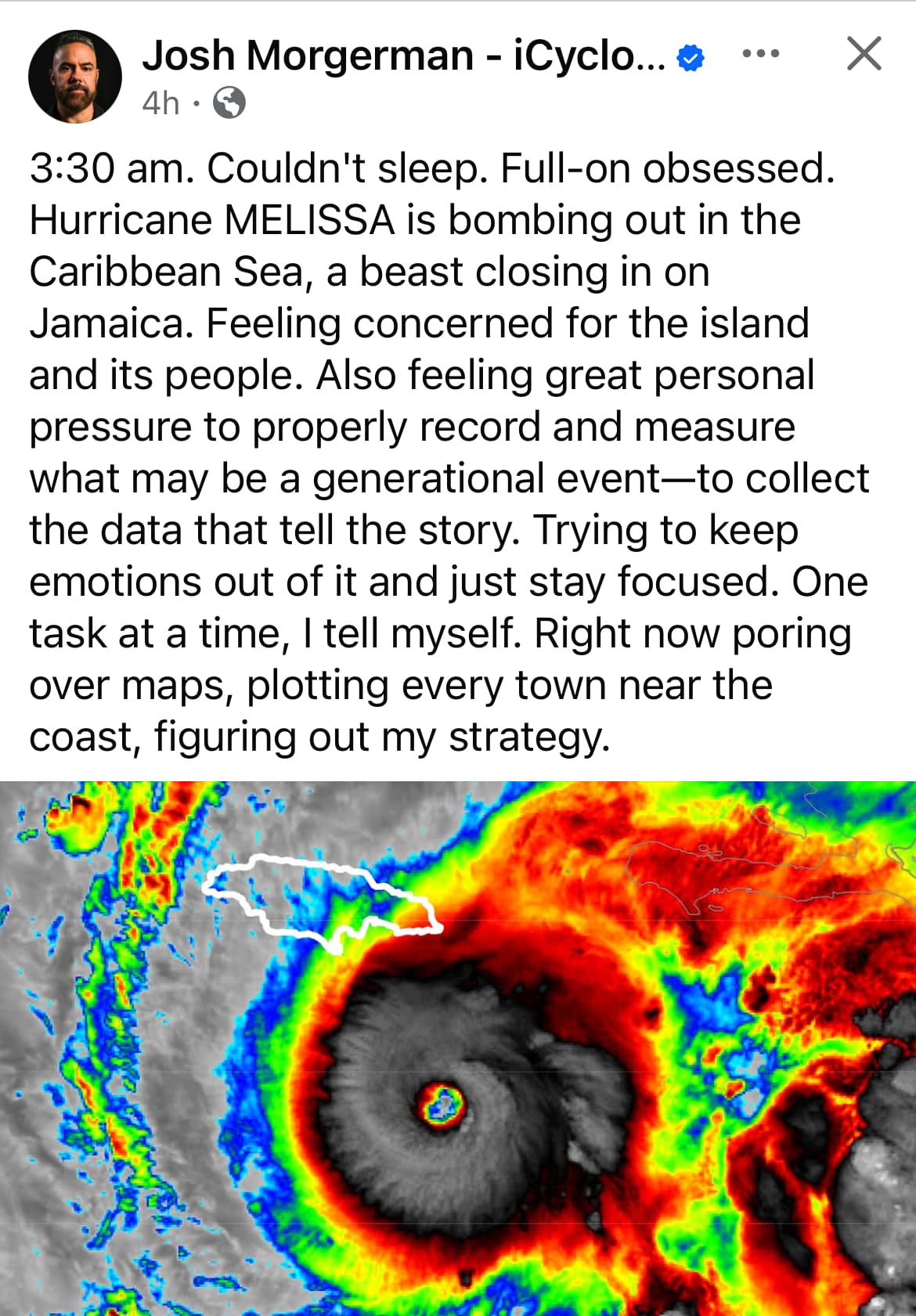
It’s a category 4 with 140 mph sustained winds and 165 mph gusts moving currently moving west at 6 mph. There has been no adjustment to the storm track, so this is probably going to be it.
In the latest update, the landfall track appears to have moved significantly west of the track it’s been the last 36 hours or so. It’s now going for a center island hit, which is away from the biggest city centers, even though large amounts of people will still be in its direct path. I’m hoping it keeps moving west before the turn.
My biggest fear with this storm is that people will get impatient at its delayed arrival and really screw up. Right now I think its projected landfall is 5am local time Tuesday. It was originally supposed to be through this on Sunday night. The more it crawls, the longer people are in lockdown, the more impatient they get. All I’ve been feeling for the last few days is a Katrina like dread.
Tampa bay was completely empty when Ian was smacking Ft Myers Beach. They got very lucky wind shear knocked Milton down, it was set to do more damage than any of these other recent nightmare storms. TB is the most exposed city in the country.
It’s basically because the forward motion of the storm plus it rotates counterclockwise in the northern hemisphere. So that’s where a lot of the energy is.
AI says the jet stream is going to move it via a changing weather pattern. I think it’s defying directional expectations so far by continuing moving west, so we’ll see. If the predictions are still on in the next update, it should begin moving WNW. I hope it’s still moving west.
Steering currents in the atmosphere. It sounds counterintuitive but stronger storms are easier to forecast. It’s why as a tropical storm, everyone was like , but now that it’s a major hurricane, they are confident in the path.
It ignored the first expected turn in the latest update. It’s still moving west at 5 mph. Still not a category 5. That also moved the projected landfall track at least a few miles further west. Keep it up.
Still bucking the forecast. It went southwest by several miles in the last update, still claiming west at 5 mph. It gets further away from Kingston with every update, has moved 20 miles further away today.