With this incompetent and intentionally negligent administration, we can expect hurricane season 2025 to be a doozy.
Continuing a trend started last year in non-favorable hurricane season conditions, Erin exploded into a category 5 from a Category 2 in about 8 hours. I seem to remember forecasts of just a few days ago expecting its max strength to be a Category 3. All those strength misses, while getting the general track right, were the same things that happened last year. Hurricane meteorologists now appear to be unable to predict the future strength of a storm even days in advance.
Erin is still expected to be no threat to the mainland for a direct hit, but any changes in certain conditions could change that. Be vigilant if you are anywhere near its path. This storm is going to have a monstrous size.
My understanding is that this season falls under normal hurricane conditions, which probably means it will be at least twice as bad as usual. I don’t think we’ve been under these conditions for at least 3 or 4 years, so this will likely be a very bad hurricane season that’s gotten off to somewhat of a slow start.
It’s gonna be a fish storm but it’s a reminder that hurricanes can explode in intensity. I think all the Cat 5 storms that hit the US were tropical storms 3 days prior to landfall.
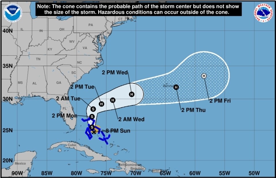
It may intensify but the track pushing TD9 out to the east is assured at this point. The pressure systems driving it out aren’t just forecast to be in place by increasingly unreliable weather models, they’re in place now. Worst weather effect it will have on the US is driving some extra moisture into a cold front sitting along the Carolina coast to make the mid week extra rainy in that area but there won’t be high winds and the flood risk is minimal.
I don’t think there’s strength certainty right now. Once again they missed on Humberto, saying its max would be cat 4 and it was a rapidly intensified cat 5. I don’t dispute it will be harder for Imelda to get going and it looks like the track is potentially going to take it off the coast (outside of rain and wind), but since the forecasters have missed on strengthening of literally every storm for the last two years, I’m dubious and keeping a close watch. If it’s stronger than expected, its interaction with Humberto could be more ‘interesting’.
This storm is making a hard right turn per the latest from NOAA and they would have to be wrong by a magnitude we haven’t seen before for it to have a huge impact on the US. Bermuda is going to get clobbered though and for their sake let’s hope the forecasts for the intensity stay minimal.
It’s been a relatively quiet season but a bad one is brewing in the Caribbean right now. It’s not projected to hit hurricane status until Saturday night, after which it’s expected to have rapid intensification to a Category 3. Not long after, it’s projected to reach Category 4 status.
I’ve been tracking this since last week when it was a tropical wave potentially headed toward the Caribbean. It had several major challenges to overcome to make it into the excessively hot and untouched waters of the Caribbean but succeeded. It’s been slowly moving and churning as a tropical storm the last 3 days.
They have wildly changed the forecast track since Monday. It was originally expected to take a northward turn and go in between Haiti and Jamaica, which would be a bad scene all around even as the Category 1 it was projected to be.
On Tuesday, they changed the forecast to it riding along the south coast of Jamaica, though each subsequent forecast has had the track drifting further and further south. I’ve seen rain predictions for Kingston go from 2-4 inches to 4-8 inches to 12-18 inches (with a max of 30 inches) over a 24 hour period.
Kingston massively floods on under 2 inches of rain, so this storm is likely going to be devastating on possibly a Katrina scale there if it doesn’t continue tracking further south. I know people are taking the storm seriously but I have a bad feeling about the city’s infrastructure being able to withstand 12-18 inches of rain. The powers that be tend to react rather than be proactive and there’s a lot of political infighting going on right now.
The next 5 days or so just for the storm (could be weeks or longer for aftermath) is going to be very nerve wracking for my friends in Ja as well as me. I really hope it keeps moving south and that it won’t be even stronger than they predict. This is the most nervous I’ve been about a storm in about 2 years.